|
Issued: 0530hrs Wednesday 30th August 2017
Duty forecaster: Garry Nicholson
 Cool, windy south-east Cool, windy south-east
Good morning,
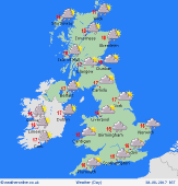
Shallow low pressure lies across the near continent, whilst slack pressure covers the British Isles. High pressure lies to the south-west. A westerly flow affects northern areas.
A complex frontal zone brings cloud and outbreaks of rain to the south & south-east, locally persistent for many hours, and a risk of some heavy bursts, but some places may escape with very little rain. Strong northerly winds around coasts in the south-east.
Brighter skies toward the north & west, with some sunshine, although a lot of high level cloud. Showers for western Scotland and Northern Ireland, some frequent bursts, locally heavy.
Today's top temperatures will be 16 to 19C, but where rain persists, it may struggle to do better than 13C.
Have a great day.
Garry
|
