|
Issued: 0530hrs Friday 20th October 2017
Duty forecaster: Garry Nicholson
 Becoming stormy in south-west tonight Becoming stormy in south-west tonight
Good morning,
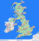
A trough of low pressure passes north-eastwards across Britain into the North Sea today, allowing a brief ridge of high pressure to move across England & Wales.
Outbreaks of showery rain in the north & east in the morning, which may persist in some areas for several hours, but brighter skies will develop across northern Britain as the day progresses.
Central & southern Britain will see stay dry much of the day, with sunny spells breaking through. Blustery westerly winds will ease for a time, then backing southerly and strengthening in the west later.
A developing Atlantic depression named 'Storm Brian' will then move in quickly to south-western Britain & Ireland later in the day, bringing heavy rain and severe gales overnight and into Saturday.
Today's top temperatures will be 12 to 15C, warmest toward the south & east.
Have a great day.
Garry
|
