|
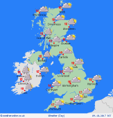 Tuesday Tuesday
A weak front across southern parts of the UK through Tuesday. This brings cloud and some spots of rain, mainly on windward facing coasts and hills with cloud shrouding these areas too. Fronts bringing rain into western Ireland and western Scotland with stronger winds here too. Drier in the east with some bright or sunny spells developing, the best of them in northeast England and eventually eastern Scotland. Highs at 12C in northern Scotland, 19C in eastern parts of the Midlands and southeast England.
 Tuesday Night Tuesday Night
A breezy night ahead with near gales in the west. Rain becomes more persistent with some heavier bursts in western Scotland, northwest England and western Scotland. Western Wales will be damp too with some outbreaks of rain here. Drier in most of eastern and central England, although a few spots of rain may affect the southwest. Lows at 8 top 12C.
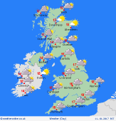 Wednesday Wednesday
A front slips south bringing rain across northern England, Wales and much of Wales. Rather windy here too. Low coud and some drizzle along southern coasts and hills of England but drier inland with broken cloud. Heavy showers in northern and western Scotland as well as western Ireland. Tending to become drier in eastern Scotland and eastern Ireland. Highs at 12 to 17C.
 Thursday Thursday
A ridge of high pressure brings some fine autumn weather across many parts of England and Wales on Thursday. There could be some early mist but this clearing quickly. Cloud and outbreaks of rain in western Ireland and western Scotland with increased winds here. Western coasts of Wales and southwest England could have some low cloud and mist at times. Feeling warm in the sunshine at 20C in southern and eastern England, 15C in the west.
|
