|
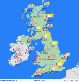 Sunday Sunday
Fronts move across the country whilst cold air stays in place. For central and northern Wales, the Midlands and far southern regions of N England there is a threat of heavy snow for many hours with significant accumulations. A mix of rain, sleet and snow for central England - snow mainly high ground. Southern regions will just see rain where it will also be very windy. Largely dry and bright for Scotland, but snow showers in the north. Staying close to freezing for most northern areas, up to 7C or 8C in south-west England.
 Sunday night Sunday night
A cold or very cold night is expected, especially across the snow cover and more generally across northern areas. Residual rain, sleet and snow is likely to continue, in a patchy nature, across more central and southern areas of England and Wales, while snow showers continue across N Scotland. In-between a lot of dry weather, with clear skies and with some particularly low minimum temperatures. Lows around -5C to +2C, but locally -5C to -10C over snow cover.
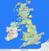 Monday Monday
Low pressure passing just to the SE of England is likely to bring a wet and windy day across SE England with the risk of the rain turning to snow across some central and southern counties of England, local accumulations possible. Across the rest of the British Isles though it will be dry after a very cold start, with sunny spells and just a few wintry showers. Highs 0C to 4C.
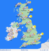 Monday night Monday night
Another very cold night across the British Isles with wet and windy weather across more southern and south-eastern counties of England clearing. Few wintry showers around coastal areas, but otherwise a lot of clear spells and turning very cold once again with a harsh and severe frost, especially over snow cover. Lows around -5C to 0C, but again below -5C is possible over snow cover.
|
