|
 Wednesday Wednesday
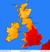
Bursts of rain & thunderstorms affect Scotland, Northern Ireland & far north of England from early morning, drifting north-eastwards through the day. Staying murky around western coasts & hills all day. Across much of England & Wales it will be hot & humid with hazy sun. Isolated thunderstorms by later afternoon. A southerly breeze. Highs 20C in Scotland, 23 to 26C Wales & N England, 28 to 31C Midlands & south-east, locally topping 33C.
 Wednesday night Wednesday night
Isolated thunderstorms with frequent lightning, hail and gusty winds are possible across central & northern Britain into the evening & night, although many places will escape these. A cold front approaching from the west is expected to bring a more organised plume of thunderstorms to Wales & the south-west into the early hours of Thursday. Murky in west - fog around coasts in south-west. Humid, lows 15 to 20C, nearer 12C Scotland.
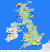 Thursday Thursday
Humid air across the south-east, whilst a cold front moves slowly eastwards. Thunderstorms across Wales & western England early morning spread to the Midlands, then eastern counties - risk several hours of torrential rain. Scattered storms in the south-east. Clusters of showers may linger in the north-west. Much of Scotland & Ireland largely dry, but rain develops from the west later. Highs 17 to 23C for many, but up to 27C in south-east.
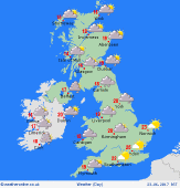 Friday Friday
A much fresher day across the British Isles. Low pressure centred north of Scotland produces a west to south-westerly breeze, strongest in the north. Largely dry with sunny spells in the south & east, whilst the west & north-west is likely to see a mix of sunshine and showers, rain locally frequent for western Scotland & Northern Ireland. Cooler than recent days for all, 14 to 17C north & west, 19 to 22C central areas, 24C south.
|
