|
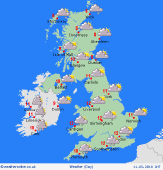 Monday Monday
Low pressure influences England and Wales, with areas of rain rotating slowly around the low. Locally, rain may persist for several hours, focused on western areas in the morning. Some thundery downpours may break out across eastern counties into the afternoon and evening. Some dry and bright intervals. Much of Scotland and Northern Ireland may escape dry most of the day with light winds. Blustery in the south-west. Highs 9 to 12C, cooler where rain lingers.
 Monday night Monday night
Residual showery rain will continue to affect central & eastern England, although will tend to fade overnight from most places. Gusty winds around coasts in the south & south-east. Local rain also possible toward the far north-west of Scotland. A ridge of high pressure builds from the west and winds will drop light for many. Clearing skies from the west. Frost likely for west & northern Britain, also Ireland; lows 1 to -2C. Nearer 3 to 6C for the Midlands & south-east.
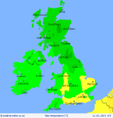
 Tuesday Tuesday
Slack pressure across Britian brings a quiet day with light winds. Most places will be dry and bright. Some early fog patches may leave murky skies for a while, but sunshine should come through for many. Chance of local showers in the far south-east. Later, fronts moving in from the Atlantic bring thickening cloud and drizzly rain to the south-west of Britain & Ireland. Strengthening southerly winds in the far west later. Highs 8 to 13C.
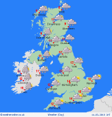 Wednesday Wednesday
Low pressure centred to the south-west pushes fronts north-eastwards across Britain. Rain on and off, locally persistent and heavy toward the west & south-west. Most prolonged falls focused over south-west England and south Wales. Eastern areas may escape drier. Blustery south to southeasterly winds, up to gale force in the south-west. Fairly mild, reaching 10 to 14C.
|
