|
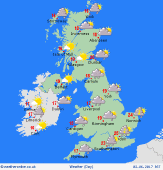 Saturday Saturday
England & Wales will be largely dry with sunny spells. Chance of an isolated shower by afternoon. Early cloud patchy rain in the south-east should break up. Showers will develop increasingly for Scotland & Ireland - some heavy bursts with possible thunder by afternoon, and locally merging into frequent rain for an hour or more. A south-westerly breeze, strongest on western coasts. Less humid, highs 16 to 21C, warmest south-east.
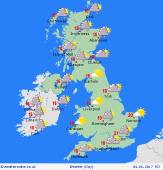
 Saturday night Saturday night
Showers will fade into the night, becoming confined to coastal areas in the north-west. Dry with clearing skies for many, although western areas may remain rather cloudy. A south-westerly breeze, mostly light, but blustery around some coasts in the west & north-west. Temperatures dipping to 7 to 10C, locally cooler in sheltered rural areas in the north.
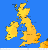
 Sunday Sunday
Low pressure lies to the north-west and high pressure to the south. Showery again for Scotland & Ireland, giving frequent rain locally, spreading from west to east through the day - some heavy bursts with local hail and thunder possible. Showers well scattered for England & Wales, and many places staying dry, with sunshine giving way to partly cloudy skies by afternoon. A south-westerly breeze. Highs 16 to 20C, warmest south-east.
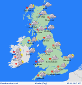 Monday Monday
An active area of low pressure is expected to pass eastwards across Britain & Ireland. Heavy and persistent falls of rain spreading to most areas through the day, but eastern Britain may escape dry for several hours - any early sun disappearing as cloud thickens from the west. Blustery winds, locally reaching gale force in the west & south-west. Up to 20C in the south-east, but 14 to 17C for most, cool in rain.
|
