|
Issued: 1000hrs Thursday 12th October 2017
Duty forecaster: Garry Nicholson
Ex-Hurricane brings a threat of severe gales
A plume of very warm and humid air extends across the British Isles this weekend due to strong southerly winds moving in ahead of Hurricane Ophelia which currently lies close to the Azores. By Monday, temperatures may soar to an exceptional 25C. This hurricane will transition into a post-tropical storm when it engages with cooler air as it approaches Britain and Ireland. However, it does bring a threat of damaging winds to the west & north early in the week.
For the weather for the next few days click here
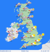 Sunday 15/10/17 Sunday 15/10/17
A dry and very warm day. Early mist and low cloud will break to give increasing amounts of sunshine, although staying quite hazy. Murky conditions and possible fog may linger around south-western coasts. A slow-moving front brings rain to north-west Scotland and the far west of Ireland. A moderate southerly breeze. Temperatures 16 to 19C north & west, but cooler far north-west. 21 to 23C in central & south-east England.
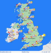
 Monday 16/10/17 Monday 16/10/17
The remnants of Hurricane Ophelia will move north across Ireland, bringing a risk of gales and heavy rain here. Strong to gale force winds are possible around Irish Sea coasts of Britain, where patchy rain may develop. A risk of thundery bursts developing in the south-west of Britain later. Elsewhere, central, east & southern Britain will be dry and exceptionally warm, reaching 21 to 25C thanks to strong southerly winds.
 Tuesday 17/10/17 Tuesday 17/10/17
A threat of gales moving across northern and perhaps central Britain overnight and into Tuesday. Rain mostly focused north & west, but a chance of a plume of thunderstorms moving out of Biscay to affect some southern parts of England. Much fresher air moves across the country from the west. Temperatures down to just 14 to 17C for many, perhaps warmer in the far south-east.
Wednesday 18/10/17
High pressure tries to rebuild across the south, although details are very uncertain by midweek. Some sunshine toward the south & east, whilst wind and rain may well return from the Atlantic to affect the north & west. Highs 14 to 18C, possibly 20C in the south-east.
Thursday 19/10/17
Strong south-westerly winds bring a risk of further heavy rain for the north-west of Britain and Ireland. The south & east should be drier, and staying mild. Highs 13 to 19C.
Friday 20/10/17
Fronts passing eastwards bring rain, most persistent in the north-west. Becoming cooler, particularly in the north, around 10 to 14C, up to 17C south-east.
|
