|
Issued: 1025 Sunday 18 June 2017
Duty forecaster: John Ejdowski
Risk of severe thunderstorms Thursday
Through Wednesday a cell of high pressure will dominate England and Wales giving quite hot, summery weather into mid week. A front could trigger some locally intense thunderstorms on Thursday. Later in the week low pressure generally gives more unsettled conditions for many. Temperatures will remain above normal through the week.
For the weather for the next few days click here
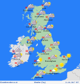
Wednesday 21/06/17
Very warm, windier and summery. Occasional showers are possible across northern Scotland and Northern Ireland. While the odd shower can't be ruled out in the south, overall it will be dry and very warm. More cloud may affect the west with central and eastern parts of England and Wales having the best of the sunshine. In the evening there is the threat of thunderstorms into the south west. Expect high of 18 to 27C.
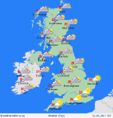
 Thursday 22/06/17 Thursday 22/06/17
A hot and more humid day across Britain. There will be some hazy sunshine around but as a front moves in, it may produce and locally heavy, thunderstorms. This may be hit and miss with many areas dry. A few thundery showers may rumble into the evening and night. Expect highs of 20 to 31C.
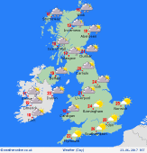
 Friday 23/06/17 Friday 23/06/17
It stays very warm across England and Wales today. An area of rain is expected across Scotland and Northern Ireland. Dry across much of England and Wales with the best of the sunshine in the south. Some rain to affect northern England and Wales then overnight. Look for highs of 16 to 26C.
 Saturday 24/06/17 Saturday 24/06/17
Today we may find a lot of cloud across Britain along with scattered showers. Best of the sunshine may be found in the south east of England with fewer showers likely across eastern areas. An area of rain may affect Britain overnight, this heavier across the north and the west. Expect highs of 16 to 24C.
Sunday 25/06/17
It looks to be another unsettled day, but confidence is low. A mostly cloudy, breezy day to come with showers in the south and more persistent rain in the north. It becomes dry for the night with clear spells. Highs of 18 to 25C.
Monday 26/06/17
A front brings rain to northern Scotland and Northern Ireland. There is a risk of showers across England and Wales. Much of Britain may turn dry into the evening and night. A warm day. Expect highs of 19 to 26C.
|
