|
Issued: 1100hrs Tuesday 20th June 2017
Duty forecaster: Garry Nicholson
Rain becoming frequent, possible thunder
A change of weather pattern will take place later this week, as the current hot spell breaks into thunderstorms, and is then followed by a much fresher westerly pattern. Next week looks broadly unsettled with low pressure in charge, bringing frequent rain and blustery winds at times.
For the weather for the next few days click here
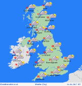
 Friday 23/06/17 Friday 23/06/17
A much fresher day across the British Isles. Low pressure centred north of Scotland produces a west to south-westerly breeze, strongest in the north. Largely dry with sunny spells in the south & east, whilst the west & north-west is likely to see a mix of sunshine and showers, rain locally frequent for western Scotland & Northern Ireland. Cooler than recent days for all, 14 to 17C north & west, 19 to 22C central areas, 24C south.
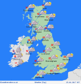
 Saturday 24/06/17 Saturday 24/06/17
Low pressure will be situated north of Scotland, producing a fresh westerly pattern for Britain & Ireland. A weakening front passes southwards bringing outbreaks of rain or showers, most frequent in the west & north-west, but some heavy bursts are possible across southern England, where it may be rather humid. Occasional sunshine. Temperatures ranging from 13 to 16C in the north-west, up to 20 to 23C in the south & east.
 Sunday 25/06/17 Sunday 25/06/17
Detail is uncertain, but many places may escape with a dry day with light winds as pressure briefly builds across southern Britain. Low pressure north of Scotland should tend to pull away, but leaves a legacy of showers and a fresh breeze for northern Britain. Another low approaches from the Atlantic, thickening cloud and bringing a risk of rain for Ireland and later western Britain. Highs 14 to 17C north, 22 to 25C south.
Monday 26/06/17
Some uncertainty, but a plume of humid air developing out of Biscay may see thundery rain spread into southern Britain. Meanwhile, low pressure to the north-west brings areas of rain or showers to many places, passing north-eastwards through the day. A little sunshine, feeling humid in the south & east. Temperatures 15C in western Scotland, up to 26C in south-east England.
Tuesday 27/06/17
Low pressure over the Atlantic is expected to push closer to Britain, bringing a risk of generally unsettled conditions into midweek. Rain turning persistent in the west, with pulses of showers advancing eastwards. Blustery south-westerly winds. Feeling fresh, 16 to 21C for most, but perhaps up to 25C in the south-east.
Wednesday 28/06/17
Broadly unsettled, with areas of showery rain, most frequent in the west. Strong winds, possible gales around exposed coasts in the west. Rather cool at 15 to 20C, although the south-east may remain warmer.
|
