|
Issued: 1000hrs Monday 7th August 2017
Duty forecaster: Garry Nicholson
Some warmer days
A cool and unsettled start to this week with areas of heavy rain encircling an area of low pressure centred over the North Sea. Eastern England has a threat of prolonged heavy rain and local flooding on Wednesday. Thursday improves for all, but rain returns from the west by Friday.
For the weather for the next few days click here
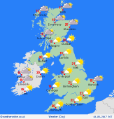 Thursday 10/08/17 Thursday 10/08/17
A ridge of high pressure builds across the country, bringing a fair day to most places with a good amount of sunshine. The south-east is likely to be rather cloudy, and the remnants of previous rain may linger early in the morning. Later in the day, cloud will thicken for north-western areas, with rain developing for Ireland and western Scotland into the night. A fresh breeze easing. Warmer than previous days, highs 18 to 22C.
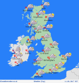 Friday 11/08/17 Friday 11/08/17
A renewed westerly pattern pushes fronts in from the Atlantic. Cloudy skies for most places, with outbreaks of rain, most persistent toward the north & west, with patchy rain spreading across the Midlands. Very little reaching the south-east, where some hazy sun is possible. Turning showery behind the rain for Scotland & Northern Ireland. A fresh breeze. Temperatures 15 to 18C north & west, 20 to 23C south & south-east.
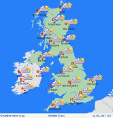 Saturday 12/08/17 Saturday 12/08/17
Fronts passing eastwards bring cloud and patchy rain to England & Wales, most persistent over hills in the west, but amounts small in the east & south. Showers for western Scotland, drier toward the east. Pressure is likely to rebuild from the west, with skies brightening for Ireland. A westerly breeze tending to ease. Highs 17 to 23C, warmest far south.
Sunday 13/08/17
High pressure is expected to extend back across the country, resulting in a brighter day for most places. A few residual showers possible, but a good amount of sunshine. Winds fairly light. Highs 18 to 23C.
Monday 14/08/17
Confidence of detail is low, but pressure is likely to remain high, focused toward the south-east. Areas of showery rain may develop across the west & north, but most places should be dry. Highs 17 to 24C.
Tuesday 15/08/17
High pressure to the south should keep many areas dry, whilst fronts passing toward the north may bring rain to the north-west. A south-westerly breeze. Highs 18 to 24C, warmest south-east.
|
